Mudeford Sandbank News
Map archive...
This archive features maps from all three publications and others from the Editors file resource.
There are others available for research or media use. Please go to the press pack page for details. If you are a student, visit the frequently asked questions page for more information.
Please Note : All maps included here are subject to their respective copyrights and should not be downloaded, duplicated, copied or used in any form of publication without prior consent of the Editor.
Map Archive
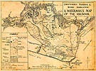
Historical Watermans Map
This is a favourite map by John Austin in 1960 by kind permission of his son, Chris Austin, of the Christchurch Sailing Club.
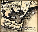
Historical Map
This map, drawn in 1791 by Faden, shows the extent of the headland before it was reduced by about a half by Ironstone Mining operations nearly a hundred years later.
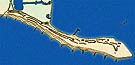
Mudeford Sandbank Map
This map of Mudeford Sandbank drawn in the 1990's attempts to show the groyne system and indicates the individual huts. North is to the right.